『伊能図集成「大図」「小図」』「大日本沿海輿地全図」小図
Digital data available(高山城下町・飛騨国絵図・高山市史街道編)
Begin reading now
デジタルアーカイブシステムADEAC
Search by Bookstore
Holdings of Libraries in Japan
This page shows libraries in Japan other than the National Diet Library that hold the material.
Please contact your local library for information on how to use materials or whether it is possible to request materials from the holding libraries.
Search by Bookstore
Bibliographic Record
You can check the details of this material, its authority (keywords that refer to materials on the same subject, author's name, etc.), etc.
- Material Type
- 図書
- Title Transcription
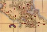
- イノウズシュウセイダイズショウズ ダイニホンエンカイヨチゼンズショウズ
- Publication Date
- 江戸時代後期
- Extent
- 1枚55.5cm、76cm
- Text Language Code
- jpn
- Target Audience
- 一般
- Note (General)
- 寸法:『伊能図集成「大図」「小図」』所収の図版寸法,原図:242.4×164.5cmカテゴリ名 : 図書出版物・関連資料 : 「高山市史編纂資料第2号 『飛騨国絵図(解説)』 高山市教育委員会 平成25年発行」第26図公開範囲 : ウェブ公開
- Collection (particular)
- 飛騨国絵図
- Access Restrictions
- インターネット公開